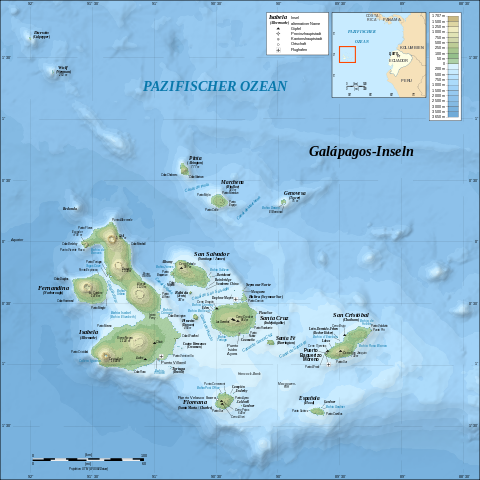
File:Galapagos Islands topographic map-de.svg

| |
This is a file from the Wikimedia Commons. Information from its description page there is shown below.
Commons is a freely licensed media file repository. You can help. |
|
Object location |
0° 30′ 0.00″ S, 90° 30′ 0.00″ W |
This and other images at their locations on: Google Maps - Google Earth - OpenStreetMap - Proximityrama | ( Info)-0.5;-90.5 |
|---|
| Description |
Deutsch: Topografische and bathymetrische Karte der Galápagos-Inseln, Ecuador.
English: Topographic and bathymetric map of the Galápagos Islands, Ecuador.
Français : Carte topographique et bathymétrique de l'archipel des Galápagos, Équateur.
|
| Date | 26 October 2008 |
| Source | Own work
|
| Author | Eric Gaba ( Sting - fr:Sting), translated by NordNordWest |
| Permission ( Reusing this file) |
GFDL / Attribution and Share-Alike required |
| |
This SVG file uses embedded text that can be easily translated into your language using this automated tool. Learn more. You can also download it and translate it manually using a text editor. العربية | беларуская (тарашкевіца) | bosanski | català | česky | dansk | Deutsch | Ελληνικά | English | Esperanto | español | eesti | فارسی | suomi | français | galego | עברית | hrvatski | magyar | Հայերեն | italiano | 日本語 | ქართული | ភាសាខ្មែរ | 한국어 | lietuvių | македонски | മലയാളം | Bahasa Melayu | Plattdüütsch | Nederlands | norsk nynorsk | norsk bokmål | polski | português | русский | slovenščina | shqip | српски / srpski | svenska | ไทย | Türkçe | татарча/tatarça | українська | Tiếng Việt | Volapük | 中文 | 中文(简体) | +/- |
Licensing
|
File usage
Metadata
Want to know more?
Through Schools Wikipedia, SOS Children's Villages has brought learning to children around the world. SOS Children's Villages is there for the children in our care until they are ready for independence. We have helped children in Africa for many years - you can help too...

