Image:Battle of Delium general map-fr.svg
Un article de Wikipédia, l'encyclopédie libre.

Battle_of_Delium_general_map-fr.svg (Fichier SVG, résolution de 1300 × 1100 pixels, taille : 493 Kio)
| | Ce fichier provient de Wikimedia Commons?. Les informations le concernant sont affichées ci-dessous (procédure). |
[edit] Summary
| Description |
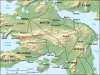
Map in French showing a large part of Antic Greece with most of the cities and places involved in the battle of Delium that occurred in 424BC during the Peloponnesian War. |
|||
|---|---|---|---|---|
| Source |
Own work ; |
|||
| Date |
March 2007 |
|||
| Author |
Eric Gaba (Sting) |
|||
| Permission (Reusing this image) |
GFDL + CC-BY-SA |
|||
| Other versions |
|


- Sujet : Carte en français d'une grande partie de la Grèce antique montrant les cités et lieux impliqués dans la bataille de Délion entre les Athéniens et les Béotiens qui s'est déroulée en 424 av. J.-C. durant la guerre du Péloponnèse.;
- Source : Réalisation personnelle ;
-
- Fond de carte : NASA Shuttle Radar Topography Mission (SRTM3 v.2) (domaine public) édité avec 3DEM de Visualization Software LLC créé par Richard Horne ; projection UTM WGS84 ; relief ombré (image composite d'éclairages du N-O, O et N) ;
- Références utilisées pour le tracé antique des côtes, les anciens lacs et la position des cités :
-
- Atlas Barrington ;
- Gustave Glotz, Histoire grecque – Des Origines aux Guerres médiques (t. 1), Presses Universitaires de France, 1948 (4e édition) ;
- Gasp. G. Mistardis, Recherches (hydrogéologiques) dans la région des lacs karstiques béotiens (École des Mines de Paris) ;
- Rose des vents : Image:Brújula.svg (modifiée) créée par Serg!o sous GFDL ;
- Auteur : Eric Gaba (fr:Sting) ;
- Date : Mars 2007 ;
- Autre carte disponible :
-
- en espagnol : Image:Battle_of_Delium_general_map-es.svg ;
- carte détaillée :
 .
.
[edit] Licensing

Historique du fichier
Cliquer sur une date et une heure pour voir le fichier tel qu’il était à ce moment-là
| Date et heure | Dimensions | Utilisateur | Commentaire | |
|---|---|---|---|---|
| actuel | 4 mars 2007 à 05:14 | 1 300×1 100 (493 Kio) | Sting | ({{Information| |Description=Map in French showing a large part of Antic Greece with most of the cities and places involved in the battle of Delium that occurred in 424BC during the Peloponnesian War. |So) |
Pages contenant l’image
La page ci-dessous contient cette image :


