
Image:Europe 1914.png
From the Simple English Wikipedia, the free encyclopedia that anyone can change
Size of this preview: 800 × 576 pixels
Full resolution (1,198 × 863 pixel, file size: 719 KB, MIME type: image/png)
| Description |
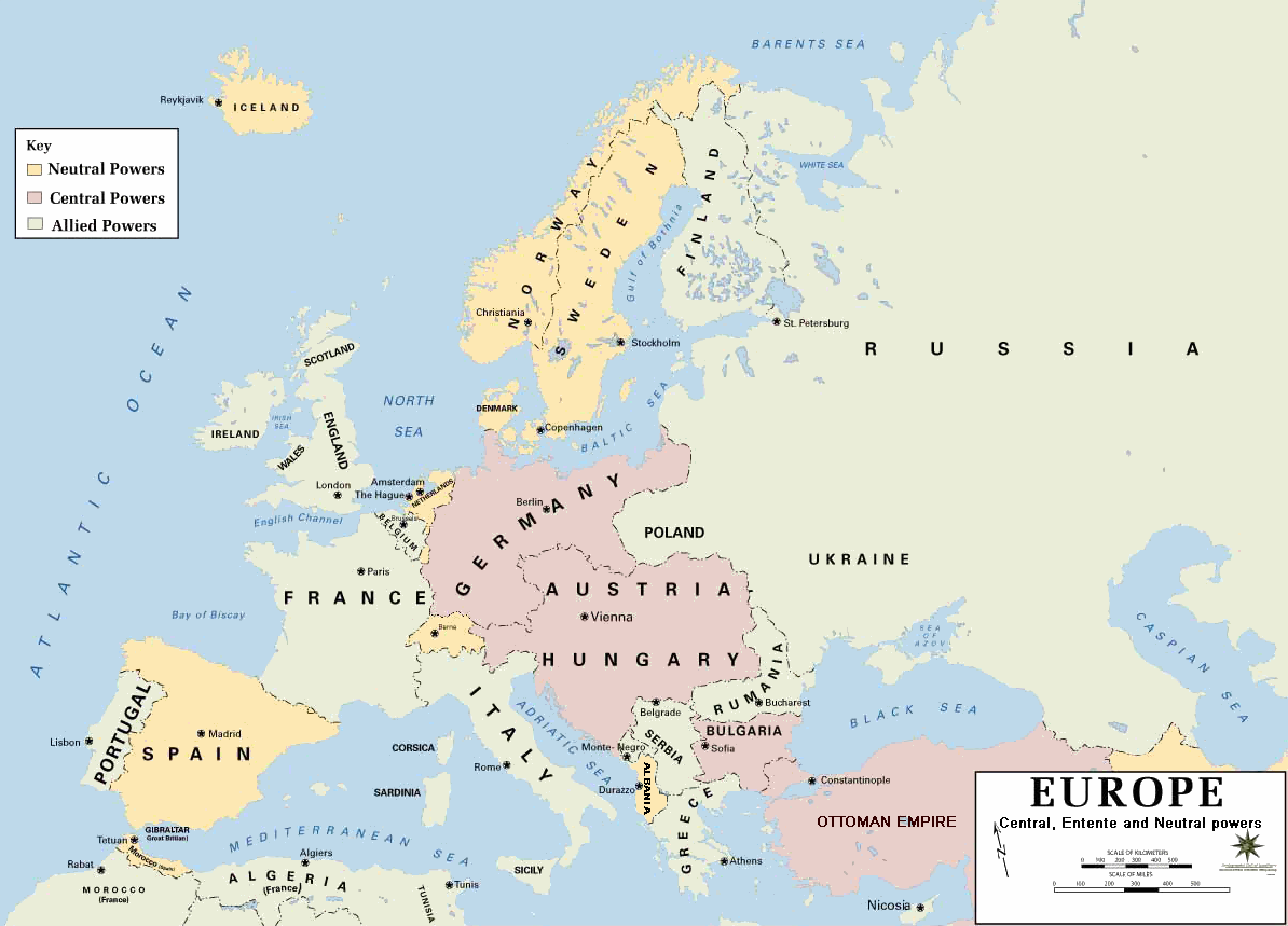
Europe 1914 |
|---|---|
| Source | |
| Date | |
| Author |
Department of History, United States Military Academy |
| Permission (Reusing this image) |
see below |
| Other versions |
|
- Background information:
In 1938 the predecessors of what is today The Department of History at the United States Military Academy began developing a series of campaign atlases to aid in teaching cadets a course entitled, "History of the Military Art." Since then, the Department has produced over six atlases and more than one thousand maps, encompassing not only America’s wars but global conflicts as well.
In keeping abreast with today's technology, the Department of History is providing these maps on the internet as part of the department's outreach program. The maps were created by the United States Military Academy’s Department of History and are the digital versions from the atlases printed by the United States Defense Printing Agency. We gratefully acknowledge the accomplishments of the department's former cartographer, Mr. Edward J. Krasnoborski, along with the works of our present cartographer, Mr. Frank Martini.
Please be aware that these maps are large in file size and may require substantial download times.
Note that in 1914 Italy and Romania declared themselfs neutral. It was only in 1915 and 1916, respectively, when they joined the Allies of World War I.
| This image is a work of a U.S. Army soldier or employee, taken or made during the course of the person's official duties. As a work of the U.S. federal government, the image is in the public domain. |
 |
[edit] Format
 |
This map image should be recreated using vector graphics as an SVG file. This has several advantages; see Commons:Media for cleanup for more information. If an SVG form of this image is already available, please upload it. After uploading an SVG, replace this template with template {{Vector version available|new image name.svg}} in this image. |
|
العربية | Български | Català | Česky | Dansk | Deutsch | English | Esperanto | Español | Français | Galego | 한국어 | Italiano | Magyar | Lietuvių | Nederlands | 日本語 | Polski | Português | Română | Русский | Suomi | Svenska | Türkçe | Українська | Tiếng Việt | मराठी | 中文(繁體) | 中文(简体) | +/- |
|
File history
Click on a date/time to view the file as it appeared at that time.
| Date/Time | Dimensions | User | Comment | |
|---|---|---|---|---|
| current | 22:56, 29 January 2008 | 1,198×863 (719 KB) | Mahahahaneapneap | (pngcrushed) |
| 08:23, 4 August 2006 | 1,198×863 (726 KB) | Wassily | (*Description: '''''Europe 1914''''' *Source: [http://www.dean.usma.edu/history/web03/atlases/great%20war/great%20war%20%20pages/great%20war%20map%2002.htm www.dean.usma.edu] *Background information: ''In 1938 the predecessors of what is today The Depart) |
Links
The following 2 pages link to this file:


