
Image:Fur map.png
From the Simple English Wikipedia, the free encyclopedia that anyone can change
No higher resolution available.
Fur_map.png (330 × 355 pixel, file size: 23 KB, MIME type: image/png)
The description on its file description page on the shared repository is shown below.
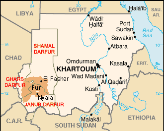
Map showing the Fur language in Sudan, following Doornbos & Bender, produced from CIA World Factbook maps
From en:Image:Fur map.png

File history
Click on a date/time to view the file as it appeared at that time.
| Date/Time | Dimensions | User | Comment | |
|---|---|---|---|---|
| current | 08:45, 2 October 2006 | 330×355 (23 KB) | Hardscarf | (Map showing the Fur language in Sudan, following Doornbos & Bender, produced from CIA World Factbook maps From en:Image:Fur map.png {{GFDL}} Category:Darfur) |
Links
The following page links to this file:


