
Image:KentuckyRiver watershed.png
From the Simple English Wikipedia, the free encyclopedia that anyone can change
No higher resolution available.
KentuckyRiver_watershed.png (300 × 221 pixel, file size: 63 KB, MIME type: image/png)
The description on its file description page on the shared repository is shown below.
[edit] Summary
| Description |
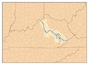
This is a map of the Kentucky River watershed, showing the North Fork, Middle Fork, and South Fork tributaries. I, Pfly, made it, based on USGS data. |
|---|---|
| Source |
Own work. |
| Date |
February 1, 2007 |
| Author |
Pfly |
| Permission (Reusing this image) |
see below |
[edit] Licensing
|
File history
Click on a date/time to view the file as it appeared at that time.
| Date/Time | Dimensions | User | Comment | |
|---|---|---|---|---|
| current | 19:17, 1 February 2007 | 300×221 (63 KB) | Pfly | ({{Information |Description=This is a map of the Kentucky River watershed, showing the North Fork, Middle Fork, and South Fork tributaries. I, Pfly, made it, based on USGS data. |Source=Own work. |Date=) |
Links
The following page links to this file:


